Introduction and Plan Overview
The following materials summarize the results of a revitalization planning process undertaken for the downtown area of the Town of Halifax, Virginia in 2002 and 2003. The plan was prepared through a highly interactive public process involving Town of Halifax and Halifax County staff and elected officials, the Town of Halifax Village Business Association, an active Downtown Improvement Committee, the Southside Planning District and consultant facilitators. Several well-attended public meetings as well as numerous newspaper articles served to both inform and involve the general populace of the community. The following public meetings were held during the preparation of this plan:
• November 6, 2002 Public Information Meeting and Merchants Meeting
• December 11, 2002 Public Hearing and Merchants Meeting
The revitalization plan is based upon several ongoing community initiatives and past plans, including:
• "Downtown Preservation Sketchbook" prepared by Johnson, Johnson & Roy/Inc. in June 1974
• Downtown Business and Consumer Surveys in July 2002
• Greenway and Pedestrian Trail Concept Designs
• Coordination with the Virginia Department of Historic Resources and the Association for Preservation of Virginia Antiquities
• Issue and Condition Inventories of the Downtown Area
Overall Project Goals
The primary goals of the community in preparing this plan are to provide economic opportunity for residents and businesses and to improve the quality of life for the citizens, not only in an economic sense, but also by providing a more attractive environment and places for public gatherings and interaction. This plan is intended to serve as a vision for the future of the downtown Halifax area and as guidance for phased funding, design and improvements to both the public infrastructure and the facades, parking and pedestrian access for businesses in the downtown area.
There have been numerous other added benefits for the community in the preparation of this plan. These include the basis for the establishment of a "Village" identity for the downtown and for the overall Town of Halifax as well setting the groundwork for a number of other initiatives. These include:
Business Incentive Package. The Town has some vacant space, most notably the former grocery store site on the east side of
Main Street south of the core business area. Community and business leaders have considered methods for attracting businesses to the Town. This plan provides materials that outline the community vision for the
future and that illustrate the commitment of the community to future economic growth and vitality. These materials may be developed into an incentive package describing opportunities within the Town for businesses to relocate.
Historic Inventory Support. The plan and the analysis materials generated provide support for the potential application for a historic district in the downtown area.
Greenways Planning and Implementation. The plan provides an initial outline of a Town greenways system that would connect to the downtown area, providing both pedestrian access for residents to the downtown and an attraction for visitors to the area. The maps included in this plan provide a basis for implementation funding and the development of use agreements.
Background and Support for Grant Applications. A primary focus of the preparation of this plan has been to provide the materials and study necessary for application for CDBG grant funding and for TEA21 grant funding for implementation. In addition, the plan provides materials to support other types of grant funding that may become available, and also provides budget and phasing information to assist the Town and the County of Halifax in establishing potential local share funding through the Town's Capital Improvement Plan and other funding sources.
History and Setting
Formed in 1752 from Lunenburg County, Halifax County is the fourth largest County in Virginia, encompassing nearly 825 square miles. Halifax County is an historic tobacco and textile industrial area of south central Virginia consisting of generally flat or gently rolling land located along the Dan and Banister Rivers. The Town of Halifax, originally called Banister, became the County seat in 1792, and is located 113 miles southwest of Richmond and 80 miles northwest of Raleigh.
Main Street from the intersection of Houston Street to the intersection of Cemetery Street serves as the core economic hub of the Town of Halifax. This area features late 19th and 20th century storefront buildings, and is anchored by a landmark early 19th century County Courthouse.
The early community most likely developed as a result of its position as the center of County government, nevertheless, Halifax has remained a small comfortable village.
Study Area
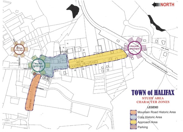 The primary study area for the project extends from the intersection of Mountain Road and Main Street south along Main Street to the railroad track and Toots Creek Bridge. The context of the downtown has also been included in the study, including the gateways at the Town boundaries and the relationship of the downtown to the Mountain Road Historic District and the Mary Bethune Halifax County office complex.
Issues
Several primary issue areas were identified for the Halifax downtown area, including:
• Overhead utilities
• Roadway and traffic design and management
• Parking quantity and accessibility
• Pedestrian use, including walks, green areas and public plazas
• Streetscape materials and themes
• Signs
• Land use and building facades and access
In order to fully study each of these areas and to develop overall recommendations for addressing the issues, several community subcommittees were formed to provide inventory and analysis. The six subcommittees included:
• Signs, Materials and Themes
• Parking, Walking and Greenspace
• Traffic
• Water, Sewer, Drainage and Sidewalks
• Overhead Utilities
• Land Use
Based on each of these issue areas, recommendations were developed for the following elements. A summary of the plan analysis and recommendations is provided on the following pages, organized around the following elements:
• Traffic and Roadway Design
• Streetscape Enhancements
• Parking
• Pedestrian Circulation
• Signs and Facades
• Community Gateways
Overall Master Plan Recommendations
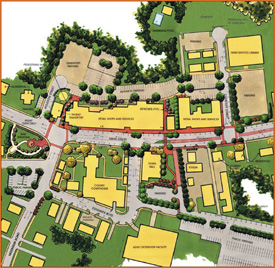
The following illustration provides an overall master plan of the study area. The study area for this project was divided into two zones, one the "Core Downtown Area" from Cemetery Street north through Mountain Road, and the other the "Approach Area" from Toots Creek north to Cemetery Street. Separate but related recommendations were developed for each of these zones. Pictures illustrating the deteriorated existing conditions are also provided.
Main Street Traffic and Roadway Design
U.S. Highway 501 is a main truck route through the Town. Along with the cars bringing people to do business at the courts and the regional jail, this highway creates a dangerous pedestrian condition throughout the business area. There are no marked pedestrian crosswalks and accidents include one fatality in recent years. The paved roadway is wider than necessary for the traffic, leading to a tendency for higher travel speeds than desired as well as to difficulty in
pedestrian crossings. The plan recommends a series of "traffic calming" measures that will address both of these issues while providing needed tree and greenspace planting areas. Typical roadway sections were developed for each zone of the roadway.
 Core Area.
The core area extends from Cemetery Street north past the Mountain Road intersection. The overall recommendations for Main Street design within the core area include:
• Relocation of overhead utilities from Main Street. Most of these will be relocated and consolidated to new poles along Houston Street. Overhead utilities were found to be one of the biggest eyesores along the core area with its narrow pedestrian walk, and the poles, often off vertical, are a hazard to pedestrian movement.
• Retention of parallel parking on both sides of the street with the parking zone delineated by chokers. Parking is essential to downtown businesses.
• Provision of dedicated left turn lanes at Mountain Road and Edmunds Boulevard.
• Provision of new curbs and sidewalks along both sides of the street. Sidewalks will be patterned concrete in a brick color
to coordinate with existing materials. The new curbs and grading will require resurfacing of the roadway paving to establish positive drainage away from the building faces. Sidewalks are in an extremely deteriorated and dangerous condition, with grade and alignment changes and large holes where poles have been removed. Due to various alterations in drainage and bad surface elevations, curbs vary from nonexistent to several inches high. The replacement of curbs necessitates resurfacing of the roadway and drainage improvements.
• Development of new drainage piping within the right-of-way to improve walkway drainage and prevent water flowing towards building entrances. Major drainage pipes for the roadway extend under buildings on the east side of Main Street. These will be abandoned and replaced by pipes running along the street with a new outfall to ravines east of Houston. The new roadway drainage will allow for the design of a more consistent curb height and better, safer definition of the pedestrian walk area.
• Addition of pedestrian scale lighting on both sides of the street to enhance safety and appearance.
• Addition of colored pressed asphalt pedestrian crosswalks at Mountain Road, the Town Hall Plaza, and at Cemetery Road to clearly define key pedestrian crossings.
Preservation Sketchbook Core Area Entry
Approach Area.
 The approach area begins at the southern gateway and extends to Cemetery Street, where it transitions into the core area. The overall recommendations for this approach area include:
• Removal of overhead utility crossing wires, but retention of the overhead wires along the sides of the road. This is recommended as a cost-effective measure, as there is no parallel route for relocation of the utilities and it is cost prohibitive to place them underground.
• Retention of most existing sidewalks and curbs except where specific repair is needed.
• Retention of parallel parking on both sides of the street with chokers to define the parking area from the travel lane.
• Provision of a continuous central left turn lane defined by terminus median islands at locations shown on the plan. This will allow safer vehicular access to Main Street by providing a continuous rest area and will allow for smoother traffic flow by removing left turning vehicles from the travel lane. It is recommended that the turn lane be treated with pressed asphalt surfacing.
This will reduce the
perception of continuous wide asphalt surface, calming the tendency of vehicles to speed and allowing pedestrians an easier crossing area.
• Addition of pedestrian scale lighting along both sides of the roadway.
Streetscape
Enhancements
Streetscape enhancements, along with the public and private signs, are the major design area where the image and theme of the community is reflected in the materials chosen. The following materials are recommended for the improvements in the downtown area.
Sidewalk Pavements. The material selected for the pedestrian walks in the core area is pressed concrete with a red brick pattern for the majority of the surface. The pattern may be varied to provide interest, with the details for the pattern type developed during the design phase of the project. This walk treatment should be used along Main Street on both sides, on the primary walks extending to the regional jail parking area and the Courthouse, and between the parking and the rear business entrances along Houston Street. It should also be used for the pedestrian connections between Main Street and Houston Street. Some areas may be treated with a slate appearance to coordinate with historic pavement areas in front of the County Courthouse. Sidewalks in the approach area should be scored concrete.
Crosswalks and Center Turn Lane. Pedestrian crosswalks and the center turn lane of the approach area should be constructed of pressed, colored asphalt with a brick pattern similar to the core area sidewalks. The pedestrian crosswalks should be provided with a reflective light edger easily noticed by the vehicle drivers. The "Streetprint" system provides effective, durable materials for this construction. The dedicated left turn lanes should be consistent in material and marking with the travel lanes.
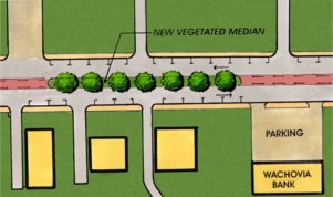 Plan Detail of Vegetated Median
Halifax County Courthouse Wall. The County Courthouse grounds are currently enclosed by a brick wall that serves as both a visual and circulation barrier, reducing the positive effect of the courthouse green and the historic building itself on the adjacent street and the downtown area. The plan recommends that this wall be removed and replaced as necessary with a low retaining wall consistent with the earlier historic treatment of the site. The wall should be constructed to match the material and style of the new Memorial Plaza wall on the north side of Mountain Road.
Street Furniture. Benches, trash receptacles, bike racks and other street furniture should be provided to encourage informal use of the public street and plaza areas. Rather than selecting one type of furniture, the plan recommends that different compatible benches be used in the various downtown areas in order to provide interest and variety.
Street Trees. The street trees for the greenspace plantings should be selected during the design phase. The trees should be carefully specified to meet the following guidelines:
• Trees should be low maintenance, with minimum leaf litter, and tolerant of road salt as well as low moisture, high temperature environments.
• Trees adjacent to pedestrian walks should be specified to allow pruning to a minimum branch height of seven feet at the time of planting.
• Trees in roadway medians and in chokers adjacent to the travel lane should be selected for a narrow crown to avoid interference with truck traffic. The branches should be pruned high enough at the time of planting to allow good visibility for the drivers of semi trailer trucks.
• Trees should be selected for consistency in specific areas but for variety along the entire streetscape. They should provide seasonal interest, including fall color and spring or summer flowering. Evergreen trees should be used in selected areas.
Parking
Parking is a major issue area in downtown Halifax. A primary driver of the parking problem is the large number of visitors to the downtown on court days. The people attending the court park on Main Street in front of the businesses and in the private parking areas located along Houston Street. Another problem with parking is the large number of signed spaces in the immediate downtown area, creating a shortage of general public parking. This includes most of the spaces along Edmunds Boulevard around the courthouse, the business parking along Houston Street, and the Town parking lot.
A major parking lot is located in the next block on the west side of Main Street adjacent to the regional jail facility. This lot, while available to the public and to workers at the courthouse, is underutilized. In addition, the Town of Halifax owns a lot on Mountain Road northwest of the intersection with Main Street. Most of the spaces in the lot, however, are currently reserved for people renting the space on a monthly basis. Most of the spaces are not currently rented, so the lot is underutilized, but not available for general public parking.
Streetscape Enhancements
The area along Houston Street behind the businesses fronting on Main Street also offers a substantial number of parking spaces. Most of these spaces are signed for individual businesses, and pedestrian access between this parking and Main Street is extremely inadequate. Some businesses have entrances on both Main Street and Houston Street, while a few businesses and residential apartments are entered only from Houston Street. Retaining and improving parking is a primary goal of the downtown revitalization plan. In order to address the parking problems, three issues must be addressed. First, parking areas need to be redesigned and improved to maximize the number and quality of spaces available. Second, directional signs to the parking and enhanced pedestrian walks to connect the parking to the businesses and the courthouse are essential. Third, a unified parking management plan must be developed, implemented and enforced in order to coordinate courthouse, employee and customer use of the parking spaces.
Improvement of parking along Houston Street is a primary recommendation of the master plan. Houston Street is currently a public right-of-way minimally maintained by the Virginia Department of Transportation. The roadway is substandard, and adjacent businesses have various parking configurations along the road, including parallel spaces and perpendicular spaces that back directly onto the road. Some of the private areas adjacent to the road have relatively unimproved stone parking areas, others have paved lots, and there are other relatively level open areas suitable for parking that currently are not used. In order to improve Houston Street, adjacent parking would have to meet current standards and perpendicular spaces would no longer be allowed. This would reduce the total parking available in the area.
The alternative recommended in the master plan is for VDOT to abandon the Houston Street right of way except for a cul-de-sac at the north end access, and for the Town of Halifax to take over the property. The Town and the adjacent property owners will develop a joint ingress-egress and parking agreement that will allow the reconfiguration of the entire area into an organized parking lot with a through lane suitable for semi trailer delivery trucks in the approximate location of the existing Houston Street. Some spaces will be reserved for individual businesses, but a large portion of the spaces will be open for public parking. The parking area redesign includes improved pedestrian access to the Houston Street business and residence entrances. The concept increases the total parking available in the downtown area, and has been endorsed by the business community. The Town is in the process of organizing a joint agreement pending preliminary design of the parking and access.
A parking inventory was prepared throughout the core study area in order to determine the total spaces available. Alternative parking
arrangements were studied and the number of
spaces available under the recommended master plan was compared to the total existing spaces. The results of this inventory are shown on Exhibit K.
Parking management and enforcement will include providing clear signs from Main Street to the various public parking areas. Court users should be directed to the lot adjacent to the regional jail facility. This should be accomplished not only through signs, but also through parking directions sent out with court notices. Signs for business parking should direct drivers towards the Houston Street lot. The Town lot should be made available for public parking, with the potential for continued limited monthly spaces signed at the rear of the lot. Short term parking restrictions along Main Street should be strictly enforced, perhaps with initial "friendly" notices provided by the merchants, who can generally monitor spaces
in front of their shops. Employees should be directed towards more distant parking spaces, freeing up the immediate spaces in front of businesses on both Main Street and Houston Street for customers.
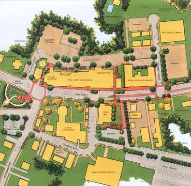
Pedestrian Circulation
Improved pedestrian circulation is critical to the success of the parking improvements as well as to providing increased safety and an attractive downtown streetscape. Attractive, direct pedestrian walkways between the improved and existing parking areas and the courthouse and Main Street businesses are essential. The pedestrian improvements are depicted on Exhibit D, the core area master plan, and also diagrammed on the following pedestrian circulation exhibit. Some primary improvements include:
• Overall improvement in walks along Main Street by improving grades; curb definition and walking surface. Removal of overhead poles will also increase safe walking width, since the sidewalk space is narrow.
• Enhanced pedestrian crosswalks across Main Street at Cemetery Street, in front of the Town Hall, and at Mountain Road. The primary crosswalk at the Town Hall includes a median "rest area."
• A pedestrian walk continuing from the Town Hall crosswalk between the buildings on the east side of Main Street to the Houston Street parking area.
• A pedestrian walk in the open area between the Town Hall and the Exxon station to the regional jail public parking.
Pedestrian Circulation Recommendations
• Connect Public Parking Areas to Main Street
• Create Safe Pedestrian Crosswalks
• Create Public Plazas
• Tie to Overall Greenway Plan
• A pedestrian walk behind the Town Hall to the Edmunds Boulevard entrance to the Courthouse Green.
• A pedestrian walk between the retail shops and Patient Transport opposite the Mountain Road intersection to provide direct access to the Houston Street parking area.
The pedestrian circulation diagram also includes a diagram of proposed greenspace walking connections to the downtown area. Halifax has considerable historic interest and a
beautiful walk in front of the historic houses along Mountain Road. A greenspace walkway that would connect this walk to the downtown area would not only encourage residents of the Town to walk to the downtown, but would also provide an activity for visitors to the region, allowing the Town to benefit from the increased interest in heritage tourism.
Another important element of pedestrian circulation is the provision of "public spaces" along the streetscape. The Town has the beginning of a series of these spaces with the new Memorial Park at the corner of Main Street and Mountain road and the historic Courthouse Green. The Courthouse Green should be made more accessible visually and
physically by the removal of the brick wall that was not part of the original building concept. The County is also considering other improvements to the circulation and design of the Green itself.
During the planning process the desire for a location for public events was expressed. The recommended location for this function is the space between the Exxon station and the Town Hall. This underutilized space was the drive-through for the bank that previously utilized the building. The drive area directly adjacent to the Exxon station extending from Main Street to the regional jail provides access to the Town police parking lot and needs to remain open. The proposed design for the public plaza is shown on the following exhibit. Major features of the design include:
• Removal of the canopy and the paving throughout the site.
• Realignment of the police parking lot to allow pedestrian access to the Courthouse Green behind the Town Hall.
• Development of an open lawn area with ornamental trees and seating areas on the perimeter. The open site will allow space for public events.
• A developed paved seating area along the front of the site continuous with the plaza in front of the Town Hall. This will provide a major seating area directly on Main Street.
• Stamped asphalt paving on the through drive aisle providing an enhanced signed access to the regional jail public parking area. This should be the primary access for court visitor and workers to reach the parking area. The drive may be closed off for special events, providing a large gathering area, since the police parking lot also has access from the rear.
• Planting screening between the Exxon site and the new public plaza.
Signs and Facades
A coordinated sign program is essential to improving the functionality and appearance of the Halifax downtown. There are two elements to address in order to accomplish sign improvements, one regarding the public signs, and the other for the private business signs.
Public Signs. An inventory of signs throughout the downtown area reveals an enormous problem with sign clutter, particularly regarding roadway identification and directional signs. There are many good examples of signs in the community, but there is great inconsistency in the character and type of public signs. Public signs should present a consistency of color and style in order to provide a clear signal that the sign includes public direction and identification.
It is recommended that the County Courthouse and facilities within the study area as well as the Town itself utilize a uniform motif for their signs. Size and specific design should be varied to address the particular purpose and importance of the specific sign. Styles and character of existing signs and architectural features were inventoried and analyzed in order to develop a uniform sign style for public signs.
Private Signs and Facades. Private signs in the downtown area should have a character and materials consistent with the historic character of the community, but should also have variety in size, color and presentation to avoid the appearance of a suburban strip shopping center. The "Downtown Preservation Sketchbook" presented excellent guidelines for private signs as well as for the improvement of building facades. Some of these basic guidelines include:
• Large projecting signs are not appropriate; small street-level signs are
• Long horizontal signs on buildings are appropriate; use multiple signs of varying design to give multiple messages
• Use serif letter styles in signs.
Several signs on downtown businesses have been constructed consistent with these guidelines, serving as a model for the improvement of other less desirable signs. As a part of the fa�ade improvement program, improved signs can be provided.
Corporate signs are another issue to be addressed within the district. Corporate signs, such as gas station and chain restaurant signs, present a challenge to historic communities. While the sign style and colors are considered critical by most corporate entities, there are many precedents for adjustments in size and support of the sign that can create compatibility with the community standards. It is essential that the Town adopt an overlay district with design standards, design review, and design assistance that includes control of the replacement and installation of new
corporate signs as well as the construction of
individual business signs. The Exxon station on Main Street will be updated in the near future, providing the potential for establishing an appropriate corporate sign type. The establishment of enforceable design standards will be essential for continued sign improvement in the downtown.
A fa�ade improvement program for the Town of Halifax will be initiated through a fa�ade grant program as a part of the Community Development Block Grant application. This program provides a 50% match for improvement of blighted fa�ade and site conditions in the CDBG area. Design and bid packages for the improvements are included in the grant. A preliminary review was prepared of fa�ade conditions, and the buildings were categorized into three divisions for fa�ade improvement budgets, high, medium and low, depending upon general visual review of conditions. During the design phase, all the buildings in the CDBG area will be visited by the consultants and fa�ade recommendations will be developed to guide bidding and construction of improvements. A sample of front and rear fa�ade improvement drawings is provided as Exhibit Q.
High level budget estimates are in the $10,000 - $20,000 range and include buildings with most apparent structural problems, requiring extensive work on brick or other materials along with sign, door and window improvements. Medium level budget estimates are in the $5,000 - $7,500 range and include extensive door and window improvements as well as signs and finishes. Low level budget estimates are in the $2,000 - $2,500 range and consist largely of sign improvements and / or painting or other finish upgrades and minor repairs. A chart in the Phasing and Budget section of this report provides a tabulation of the structures.
RECOMMENDED SIGNAGE
 The "Downtown Preservation Sketchbook" provides excellent initial guidance for the improvement of facades. Starting from these guidelines and principles, a sample fa�ade design for both a Main Street and a Houston street face was prepared. The major guidelines for fa�ade improvement include:
• Single story structures are not in scale with existing downtown buildings - any new construction should recognize existing building scale
• Desirable rhythm created by two or more buildings together
• Stucco/plaster, plastic and porcelain are not appropriate - existing appropriate materials for Halifax are brick and wood
• Contrived colonial details are not appropriate; foreign stylistic design elements such as mansard roofs are not appropriate; use details appropriate of turn of the century
• Metal awnings are not appropriate; canvas awnings are most appropriate
• Large horizontal paneled windows are not appropriate; old character is vertical proportioned windows
• Large panes on windows should be divided to give a vertical impression
• Do not paint existing red brick; paint major wood and accent elements off-white, use brighter accent color on narrow trim elements
Community Gateways
Several gateway areas were identified during the planning process, including major gateways into the downtown area, but also including community gateways located on the major highways at the Town of Halifax boundaries. The plan recommends a simple sign consistent with the overall public sign design themes at the Town boundaries on all of the major roads into the Town. In addition, three major gateways into the downtown area were identified.
• Mountain Road Gateway at the intersection of Mountain Road and Main Street
• Northern Gateway at river bridges
• Southern Gateway north of Toots Creek and railroad crossing
Mountain Road Gateway. This gateway is the primary entrance into the downtown from the west. The Mountain Road Historic Area is an extremely attractive entrance into the downtown, but the approach to Main Street from the west and the intersection are badly in need of improvement. The area has inconsistent curbs, confusing traffic patterns, too many signs mounted in ways that impede pedestrian movement, inadequate pedestrian crossing markings, and poor building presentation. The recommendations of the plan include:
• Reduce the number of highway identification and directional signs as much as possible, and organize them in groupings with attractive supports in order to reduce the visual clutter of the corner.
• Relocate the overhead utilities around the Veterans Memorial and the Intersection of Mountain Road and Main Street.
• Improve the Town of Halifax parking lot on the north side of Mountain Road with additional frontage greenspace and trees.
• Improve the site conditions of the buildings at the intersection, reducing the curb cut length and adding greenspace enhancements. The buildings themselves require only minor fa�ade improvements, but the sites present an expanse of pavement and undefined curb line.
An alternate recommended improvement for this gateway area is to close the connection of Maple and Mountain Road, providing access to Maple only from the connection to Main Street north of the Mountain Road intersection. This would improve the appearance of the intersection area, and more importantly, would increase the safety of the intersection for vehicles and pedestrians by removing one of the offset intersecting streets. It would also reduce cut-through traffic in the Maple Road neighborhood.
Detail plans of the recommended gateway improvements as well as of the alternate Maple Avenue closure follow.
Northern Gateway. The Northern Gateway to the downtown is identified by the two bridges crossing the river and reservoir at the Town boundaries. These are attractive natural and cultural features that establish a good sense of place and character for the Town. Gateway treatments at these locations can be simple and attractive. The following are the recommendations for these locations:
• Provide a gateway sign on the Town side of each bridge.
• Organize existing highway identification and directional signs to reduce visual clutter.
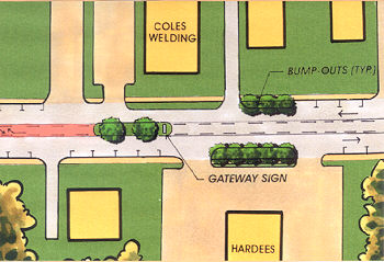 Southern Gateway. The Southern Gateway to downtown was first considered to be located at Toots Creek and the railroad crossing. The plan recommends, however, that the formal downtown gateway be located on Main Street north of the railroad crossing. A curve in the road at the transition from the more intensive gas station and restaurant businesses to a more residential character provides a better transitional area into the downtown.
It is critical, however, to clean up and enhance the Toots Creek bridge and railroad crossing area. A major issue with the appearance of the approach to the downtown area is the Roller Mill located on the east side of Main next to the railroad. While the structure is of considerable historic interest, it is very dilapidated and has a negative effect on the perception of the Town. Although there has been some consideration of renovating the building for a new use, it is difficult to reuse the building due to the lack of parking for business use. It is important to go beyond stabilizing the structure, and to actually improve the appearance or else to remove it.
The following plan view and photo enhancement illustrate the recommendations for the major Southern Gateway entrance to the downtown. The recommended improvements are summarized as follows:
• Provide a wide median in Main Street with a gateway sign, trees, and seasonal planting.
• Slow traffic with chokers along the parking lane south of the median island and sign, including enhanced plantings along the front of Hardees and the residence on the east side of Main.
Next Step Implementation
A community revitalization effort is necessarily a partnership between the public entities and the private business owners and residents. The preparation of the Town of Halifax revitalization plan has been a model of community cooperation, with continuous involvement of both the Town of Halifax and Halifax County, which commissioned the study, as well as the efforts of numerous dedicated community members. This type of dedicated and committed involvement leads to implementation efforts even during the planning process. Recognizing that a plan is a snapshot in time, and that the Town will continue to evolve and change, as it has in the past, is fundamental to successful improvement efforts. The Town and its citizens during the planning have begun improvement of the buildings, are considering private proposals in light of long-range goals, and are working on a cooperative plan for addressing parking needs and management. In addition to designing, funding, and constructing necessary improvements, the following issues should be addressed in the near future and on an on-going basis:
Parking Management. It is critical that the Halifax County courts, the Town of Halifax, and the private business owners and property owners in the downtown area develop an overall parking management plan. This should address maintenance, directional signs, parking time limitations, a distribution of shorter-term customer parking in convenient areas, and guidance on court day long-term parking. Enforcement of parking time limitations is critical to the success of the management plan.
Downtown Overlay District and Design Standards. The Town of Halifax, through the "Downtown Preservation Sketchbook" as well as the recommendations of this plan, has guidance for the preparation of a Downtown Overlay District with associated design standards and zoning regulations. In order to guarantee the quality of design and construction in the future as well as to guide appropriate land use changes, zoning ordinances that support the design goals established in this plan should be implemented.
Funding and Phasing
Two primary programs have been identified for potential implementation of the recommendations of this plan. One is the Community Development Block Grant program administered through the Virginia Department of Housing and Community Development. The other is the utilization of TEA21 transportation enhancement funding administered by the Virginia Department of Transportation. A focus of the plan has been to define a scope of activity that will be eligible for funding under these programs and that will fit within guidelines for potential funds available.
Community Development Block Grant.
The CDBG program is intended to address blighted conditions within a defined boundary within a community. The funds may be used to address public space improvements and also as a 50% match to private landowners to address visual blight through the improvement of building signs, facades and building access. The CDBG area for downtown Halifax extends along Main Street from Cemetery Street to
Mountain Road and includes the deteriorated sidewalks and curbs as well as the signs and building facades. The rear facades of the buildings between Main Street and Houston are also included in the CDBG area, since many businesses have a dual point of access from both Main Street and Houston Street. The CDBG area is shown on the "Phasing Budget Plan" exhibit.
Conditions to be addressed in this area have been discussed in the sections describing the existing conditions in the community as well as in the plan recommendations. The primary issues may be summarized as follows:
• The sidewalks are extremely deteriorated, with irregular surfaces, holes, grade changes and other dangerous and unattractive condition. The curbs are also variable, in poor condition or nonexistent, and in need of complete replacement.
• Streetscape enhancements are planned as part of the sidewalk improvements. These improvements will include public plazas and pedestrian improvements including safe dedicated pedestrian crosswalks and connections between the businesses and the downtown parking areas.
• The roadway has been resurfaced numerous times and has a drainage system that runs under the private buildings. In order to improve the drainage and sidewalks the street must be regarded and provided with a new drainage system.
• The water and sewer for the area have been checked on a preliminary basis, and should not require any improvement as a part of the project.
• The building facades and signs are variable in condition. Some have been improved and maintained over the years and need only minor improvement to address visual blight, while others are in extremely blighted condition and need more major improvement and change. Some buildings have been undergoing improvement during the planning stage of the project. The 28 buildings slated for improvement in the grant area have been divided into high, medium and low cost categories. The categorization and a brief summary of recommended improvements for each building are provided on Exhibit W.
• Public sign blight will also be addressed as part of the streetscape improvements to address the visual clutter, unsafe mounting, and lack of clarity of public directional and identification signs.
TEA21 Enhancement Grant. TEA21 grants are funded under the Federal Transportation Enhancement Act, with funds passed through the Virginia Department of Transportation for distribution to communities. The grants require a 20% local match, and may be used for public pedestrian and bicycle access improvements, along with related streetscape, utility and roadway work and removal of overhead utilities, and also for improvement of transportation-related facilities, including historic elements. In the Town of Halifax, funding applications will require phasing in order to address the full project scope. The Town has received a design grant available in 2003 for design of the Phase One improvements. A Phase One TEA21 construction application will include the relocation of overhead utilities on Main Street. Additional improvements have been broken down into several areas for phasing purposes, as shown on Exhibit V and summarized in the Exhibit X budget estimate.
Overall Project Budgets
The total public cost of the proposed improvements in this plan is approximately $1,980,000. The overall budget is divided into six main areas with approximate budgets as follows:
Main Street Core Area
Streetscape and Facades $615,000
Main Street Core Area
Overhead Utilities $400,000
Plaza and Pedestrian Areas $120,000
Main Street Approach Area $305,000
Houston Street Improvements $315,000
Courthouse Area $225,000
Back to The Town of Halifax home page.
|